

Warning is in effect until 11 a.m. Wednesday
The National Weather Service in Portland has issued a Flood Watch for the Columbia River at Vancouver affecting the greater Vancouver area. The Flood Watch warning will go into effect at 3 a.m. Sunday (June 12) and continue until 11 a.m. Wednesday.
Periods of heavy rain over the past 48 hours combined with melting snowpack in the mountains has resulted in rising river levels. Flows in rivers may increase quickly and reach critical levels. Residents and those with interests near the river should monitor rising water levels and be prepared for possible flood warnings.
Those who are in the watch area should remain alert to possible flooding. Additional information is available at www.weather.gov.
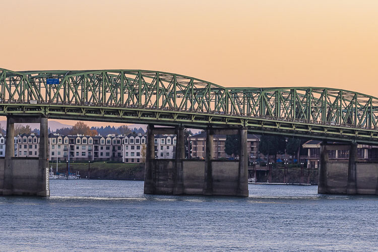
According to the Oregon Department of Transportation, travelers on Interstate 5 should expect more frequent lifts of the Interstate Bridge in the days ahead because of the increased level of the Columbia River.
The river level is expected to exceed 15 feet by early next week. The flood stage at that point on the river is 16 feet. That will mean longer lifts of the bridge spans as both upstream and downstream river traffic must use greater caution in navigating through the faster water.
The river level at the Interstate Bridge is generally six to seven feet.
Bridge lifts can sometimes be completed in six to eight minutes but lifts now are expected to last up to 20 minutes.
The increased river level has reduced the clearance at the high span, which is at the hump in the bridge at mid-river. That causes more marine traffic to use the lift span along the north side of the river. More lifts bring more delays on I-5.
Under maritime law, marine traffic has priority over I-5 highway traffic. However, no lifts are allowed during the morning and evening commute times weekdays from 6:30 a.m. to 9 a.m. and again from 2:30 p.m. to 6 p.m. except for federal holidays.
Recent rain throughout the Columbia River Basin has contributed to the high water. The Columbia River dams help regulate river volume.
The Columbia River reached the flood stage at the Interstate Bridge in 2017, when it reached 18 feet, and in 2011 when it reached 19 feet. The highest level in recent years came in 1996 when the river reached 24 feet.
The Interstate Bridge is jointly owned by Oregon and Washington and is operated and maintained by ODOT. The northbound span opened Feb. 14, 1917 and the southbound span July 1, 1958.
Also read:
- WA governor pressed to veto $1.8B piece of Democrats’ tax bill
 Grocers and restaurateurs are urging Gov. Ferguson to veto a surcharge in HB 2081 that they say will raise food prices statewide.
 - CCSO makes arrest in attempted kidnapping investigation
 A 31-year-old Vancouver man has been arrested in connection with an attempted kidnapping involving a teenage girl near NE 149th Street.
 - Changing roles: Brian Witherspoon accepts position as head coach of Camas girls basketballBrian Witherspoon has been hired to lead the Camas girls basketball program after serving as interim boys coach last season.
- Vehicle crashes into Vancouver Fire Station 6 during emergency responseA vehicle crashed into Vancouver Fire Station 6 late Tuesday night while crews were out on an emergency call.
- Letter: ‘It’s said sarcasm is the lowest form of wit’Amboy resident Thomas Schenk criticizes Olympia’s use of “emergency clauses” and other legislative tactics that limit public participation.
- Letter: ‘We’re going to give them some money and a plane ticket, and then we’re going to work with them’Camas resident Anna Miller supports a new structured self-deportation policy, calling it a balanced approach to immigration and economic needs.
- Pro-Palestinian protesters occupy UW building, 30 arrestedAbout 30 protesters were arrested at the University of Washington after occupying a building and demanding the school cut ties with Boeing.


As I always say, you can drive Interstate 5 from Canada all the way to Mexico (over 1300 miles) and the only place you may have to stop is when some sailboat is passing under the interstate bridge. Soon, it will also be the only place where tolls are paid.
“Tolls are coming to the I-5 and I-205 bridges, and they’re coming more quickly than you would think.
Earlier this month, the Oregon Transportation Commission circulated a memo with an update on the Interstate Bridge Replacement Program (IBR). That memo declared, “Tolling would begin in late 2025 to early 2026.” In a slideshow to the commission, one of the slides projected, “I-205 tolling launches by the end of 2024.” ”
full article Opinion: Plans are in place to force Oregonians to pay for the privilege of waiting in traffic
Extra tall recreational sailboats can call for a personal bridge lift at 6.01 PM on a weekday during what is now peak traffic time while freight, commuters, and the few transit riders wait. This old policy is out of date, and does not reflect the current “peak” traffic commute times on I-5. Bridge lifts on the weekends and holidays anytime it seems. When was this policy established? Has it been reviewed in the last 20 years? Fishing limits and seasons have been adjusted over the years. Seems high time to review more reasonable limits on bridge lifts.