

Lance Killian at Columbia Business Center defends need for a higher bridge for maritime community
John Ley
for Clark County Today
At Tuesday’s Interstate Bridge Replacement (IBR) Program meeting of the Executive Steering Group (ESG), new visualizations of three possible bridge designs were shown. Two hours later, the same information was shared with the Regional Transportation Council (RTC) Board. The designs continue to reflect the program’s desire to build a structure with only 116 feet of clearance for marine traffic, with one option having a movable lift span.
IBR Administrator Greg Johnson spoke about finalizing the Draft Environmental Impact Statement (DEIS) later this year. It will be a 9,000- to 10,000-page document. Citizens will have 60 days to review it, and offer public comment. Johnson’s team is planning two public meetings for hearing citizen input during that 60-day period.
“We know the number is going to be higher,” Johnson told the RTC Board in reference to the current $5 billion to $7.5 billion price tag. In December, he told the 16 legislators of the Bi-State Bridge Committee the cost was going up. His team will release new cost estimates perhaps in June. They are using a Washington Department of Transportation (WSDOT) cost evaluation process for their update, Johnson shared.
At the ESG, it was mostly cheerleading and positive comments by community leaders. However Vancouver Mayor Anne McEnerny-Ogle called one graphic ugly, saying “the overhead power lines makes me think I’m in a third world country.” She was referring to the electric lines for light rail.
That was not the case at the RTC Board, where Clark County Councilors Gary Medvigy and Michelle Belkot raised some of the concerns many people have with the current proposal. Tolling is getting increasing public opposition, Belkot noted. She sits on ODOT’s Regional Tolling Advisory Committee (RTAC) on behalf of Clark County where ODOT and the committee were recently called “tone deaf.”
Medvigy raised people’s opposition to light rail, asking why the most expensive component of the project couldn’t become a separate project when there was actually enough demand for high capacity transit. He encouraged the use of buses for now. The Clark County Council position has been asking for significant traffic congestion reduction and no tolls on the bridge.
Presently it takes an average pf 29 minutes to travel from Salmon Creek in Vancouver to Portland’s Fremont Bridge on I-5. The IBR projects travel times will double to 60 minutes in 2045, a decade after they complete their proposed project. They also estimate half of all rush hour vehicles will be stuck going zero to 20 miles per hour.
Johnson responded to Medvigy with the often used line “we can’t build our way out of traffic congestion.” Citizens are frustrated that they’re not even trying, given that the IBR proposes to replace an over congested 3-lane bridge with another 3-lane bridge. Medvigy pushed back, noting the need for additional transportation corridors.
It’s been over 40 years since a new transportation corridor (I-205) was built. The 2008 RTC “Visioning Study” identified the need for two additional bridges and transportation corridors; one west of I-5 and the other east of I-205. Medvigy wants more emphasis on congestion relief. The $2 billion light rail extension adds to pressure for tolling to raise money for the overall project.
The RTC reports in 2021, there were 131,000 average daily Interstate Bridge crossings. Johnson expects 170,000 in 2045. Ironically at the meeting, the RTC approved the creation of strategies to reduce Vehicle Miles Traveled (VMT) to meet state planning requirements.
The RTC also has a Congestion Management Process. Their 2018 report says: “Both Columbia River bridges are suffering daily congestion during morning and evening peak periods. The Interstate Bridge had reached capacity during peak hours in the early‐1990s, and the Glenn Jackson Bridge in the mid‐2000s.” The lack of capacity was known long before the current bridge discussions began.
Belkot also asked for an update on the Coast Guard clearance issue. Coast Guard officials are are demanding a structure that offers at least the current 178 feet of clearance for Columbia River marine traffic. They would prefer unlimited clearance, which could be provided by either a bascule bridge or a tunnel.
The current IBR proposal is for a bridge that offers 116 feet of clearance, the same as was requested in the failed Columbia River Crossing project a decade ago. Before that project was stopped, they agreed to pay $86.4 million in “mitigation” to three up-river firms. Currently, there are four firms the IBR is in discussions with over the bridge being too low.
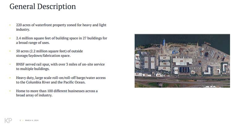
Lance Killian is manager of the Columbia Business Center and he raised significant objections to the ESG about the bridge height. He shared a 4-page letter sent to the Federal Highway Administration (FHA) and Federal Transit Administration (FTA) last fall which highlighted their role as a primary facility for maritime use of the river.
Killian shared the CBC’s facilities cannot be relocated, and pushed back on the IBR narrative that the upriver firms are working with the IBR. “CBC will take those steps necessary to protect its position,” Killian stated during public comment.
The CBC letter noted the loss of tax revenue and employment. They noted the “functional obsolescence” that would be caused by a 32 percent reduction in vertical navigation clearance with the current IBR proposal. Killian wants to “avoid pursuing alternative paths” which could include lawsuits that would slow down the entire process. He copied lawyer Steve Horenstein on the letter along with three different individuals in the Coast Guard.
“If the Interstate Bridge Replacement vertical navigation clearance were lowered to 116 feet it would permanently, materially adversely impact the viability of Columbia Business Center for existing and future uses, in particular heavy manufacturing in existing and future industries related to national security (ie. war ship and material construction), climate change and energy (ie. large wind energy and oil derek components), and critical regional and national infrastructure.”
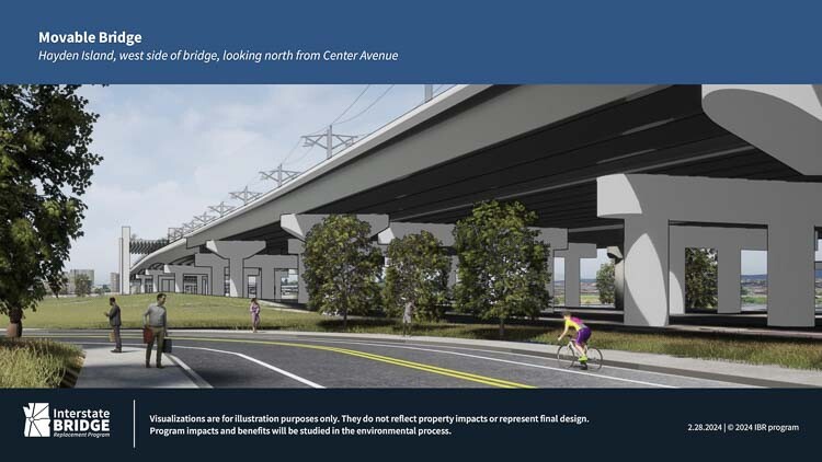
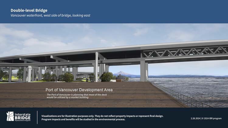
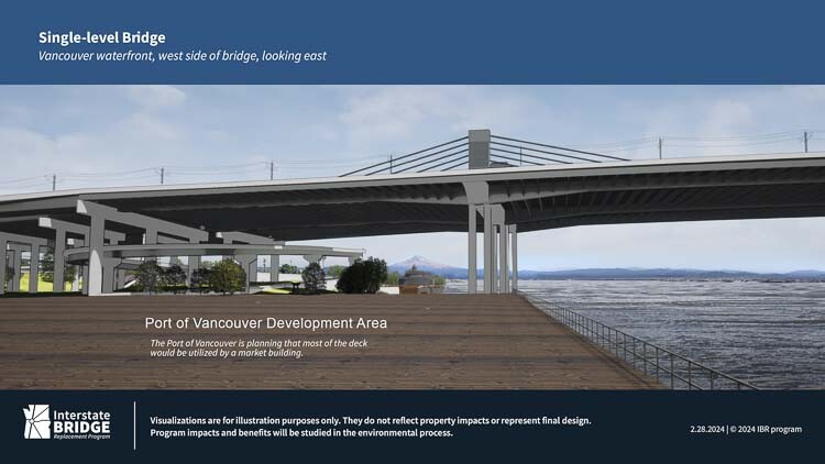
The new “visualizations” showed views from both Vancouver and Hayden Island. None demonstrate how wide a footprint the bridge or bridges will take. One shows people walking and biking on the west side of the bridge on Hayden Island. Another shows pedestrians and bikers on a wide “shared use path” on the same level as the freeway vehicle traffic.
There is a “double truss” bridge – two levels. And then there is a movable span bridge which is south of the current movable span bridge location. They offer an “extradosed bridge” with cables to support the structure that may provide some aesthetic value. None showed the Vancouver waterfront transit station, which supposedly will be 75 feet in the air above the BNSF rail tracks.
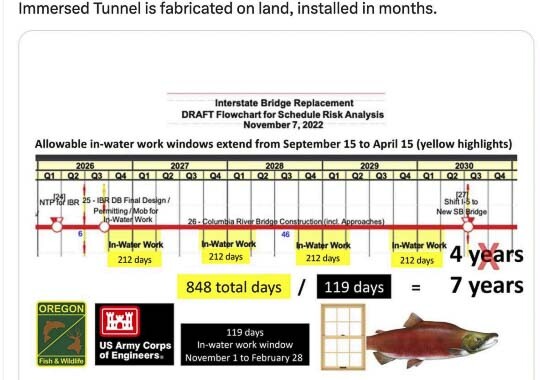
Johnson expects to begin “in water” construction work in September 2026. He noted that if they miss this construction window, the project slips one year and that could add $300 million to the cost (in 2035).
Retired engineer Bob Ortblad has been pushing back on the IBR timeline for their in water construction. The IBR plans for 212 days of construction in the river each year, whereas Ortblad reports federal authorities only allow 119 days. This is to protect fish in the Columbia River. Ortblad prefers an immersed tube tunnel for the crossing, citing efforts in Antwerp and Vancouver, BC.
Ortblad shared with Clark County Today the NOAA “fish window” is 119 days, from November 1 thru February 28. The IBR is planning for September 15 thru April 15 for in water construction.
Both Johnson and RTC Director Matt Ransom highlighted the recent $600 million federal allocation to the project. They each mentioned the recent visit of DOT Secretary Pete Butigieg to promote the project. “This is getting close; the funding is real,” Ransom said.
Johnson called their application for $1 billion in funding from the FTA an “open book exam”, indicating the agency is working with them. The FTA grant would only cover at most half the current $2 billion cost of the 3-mile MAX light rail extension into Vancouver. TriMet is demanding new taxes from both states to cover operation and maintenance expenses.
The IBR also plans to begin “pre completion tolling” in late 2026. The Washington and Oregon Transportation Commissions established a subcommittee which began meeting to set bridge tolls.
An IBR issued press release with the visualizations stated the following, attributed to Greg Johnson, program administrator:
“In today’s Executive Steering Group meeting, we presented new visualizations of some of the design options being considered as we continue to work through the environmental phase of the program. These new images show each of the bridge configurations (single-level, double-level, and moveable span) being analyzed in the Draft Supplemental Environmental Impact Statement from different viewpoints close to the proposed structure or while traveling on the shared use paths in these areas. The images include one example bridge type for each of the bridge configurations: extradosed bridge for single-level, truss bridge for double-level, and girder bridge for a moveable span. They do not represent a complete range of bridge types being considered. No decision has been made on the bridge type or configuration at this time.”

Also read:
- Clark County beginning installation of upgraded traffic signals in mid-April
 Clark County will begin upgrading multiple traffic and pedestrian signals in mid-April to improve safety, accessibility, and transportation technology.
 - Can $10 tolls be coming to the Interstate Bridge?
 Rep. John Ley examines a proposed Washington House bill that would double borrowing for the Interstate Bridge Replacement and potentially lead to high tolls affecting Southwest Washington drivers.
 - Overnight full closure of I-5 in north Clark County for utility work, April 13Both directions of I-5 in north Clark County will be closed early Sunday morning, April 13, for utility work involving overhead power line relocation.
- Opinion: The stage is set for a battle royaleRep. John Ley outlines key legislative battles in Olympia, raising concerns about tax hikes, tolling, and spending priorities in Washington state.
- Inflation worries drive WA lawmakers to jack up I-5 bridge borrowing plan by $900MLawmakers in Washington have added $900 million to their borrowing plan for the I-5 bridge replacement, drawing opposition from Rep. John Ley.


Yes, the MAX light rail electric lines that run overhead are ugly. They also freeze and ice up in winter, and overheat in summer, shutting down the MAX trains. Ice also gets embedded in the tracks, stopping the MAX. Shuttle buses on the roads are then used to transport commuters when the MAX goes down. Buses generally keep running, sometimes with chains, albeit on snow schedules in winter. MAX lines went down in December, 2022, and were disrupted or delayed in the Feb. 2023 snow and ice storm. On Saturday January 13, 2024 snow and ice on the overhead lines and on the tracks disrupted MAX light rail. Two of the MAX lines resumed some service by Friday evening Jan. 19, and others remained closed.
A new bridge across the columbia? Never happen….
Can you say “CRC v.2” ????
You know, at this point, I’m of the opinion that this current effort needs to also be halted, as was the prior planning effort.
It appears that the planners have a predetermined design with predetermined features such as light-rail. Neither the proposed designs (no increased traffic capacity), nor the proposed features (inclusion of light-rail, with tolls) are what the public is demanding.
Sure, they’ve had public hearings and public comment sessions…. which all seem to have fallen on deaf ears. But, hey, they put a tik-mark on that all-important checklist!
And now, Killian/CBC are reminding the planners – and properly, I might add – that the USCG has yet to approve the planned height, nor do they (CBC) plan on sitting on the sidelines and watch their business capabilities be taken away. Good for CBC for speaking up!
Scrap it all !! Get out the blueprints for the Glenn Jackson bridge and let’s build a simple, functional, multi-lane bridge that does what it is supposed to do… move cars, trucks, and high-capacity buses across the river. Without tolls.
And don’t let ’em convince you that “it ain’t happening that way.” It CAN happen, for far less money than the current Taj Mahal boondoggle.
Susan — spot on.
As for the “plans for the Glenn Jackson Bridge”, we actually had an offer, with design, for an East County Bridge. If built at 192nd, the price was about $840 million. If built at the narrower Troutdale to Camas location, $800 million.
Here are the details. https://eastcountybridge.com/
Great article!! Thank you John Ley and Clark County Today!
The IBR should NOT be continuing to shove aside the USCG’s marine traffic vertical height requirements. Now, because of your article, I know more about the heavy manufacturing related to national security that is being done at the Columbia Business Center. It is so clear that this established manufacturing industry adds another powerful reason to ensure that the right bridge is built.
The USCG recommended two suitable bridge designs that would provide the right bridge clearance height. The Bascule-style, or Immersed Tube Tunnel. It is such a huge waste of time and money that IBR continues to plan any 116-foot vertical height clearance bridges! I hope that the decision-makers hurry up and strongly pull in the IBR’s reins.
THREE BRIDGES!
Stupid is as stupid does….if Clark County keeps electing Democrats…..keep expecting stupid ideas that no one wants.
Oh my gosh! All this over the same issue. What do “we the people” want? I am glad you asked. NO LITE RAIL. Use a single level, three lanes each way, plus a fourth lane for mass transit (bus) ONLY lane, high enough to avoid lifts for river traffic. NO TOLLS. Our transportation taxes are enough. We have lived in Clark County since 1971. We lived in Skamania for six years before that, so I am familiar with transportation issues between WA and OR. I think my recommendation is solid. Let’s do it.
“Coast Guard officials are are demanding a structure that offers at least the current 178 feet of clearance for Columbia River marine traffic. They would prefer unlimited clearance, which could be provided by either a bascule bridge or a tunnel.” A bridge that would give 178′ of clearance below the bridge for river vessels to go under would be a behemoth, casting dark shadows on the riverfront and downtown. A tunnel or bascule lift bridge seem better suited to current, and future river navigation, and preserve the waterfront and downtown area. Using buses and vans instead of light rail would greatly reduce the cost either a tunnel, or a bridge.
The scaling is still way off. At the Columbia River’s edge where the Quay used to be the height will have to be 187 feet…to the bottom of the structure. Looking up you will think it is one ugly eyesore. Because, it will be way up there and huge. No one will draw the pictures to actual scale because then everyone will get the true picture on the magnitude of the size. To begin the rise so light rail can cross over the new bridge it has to start way up at 39th street. The new bridge has to have that long of a stretch of road to get the slope down to the right angle for light rail. Don’t be fooled. This monster bridge all because of the light rail component changes the design criteria.