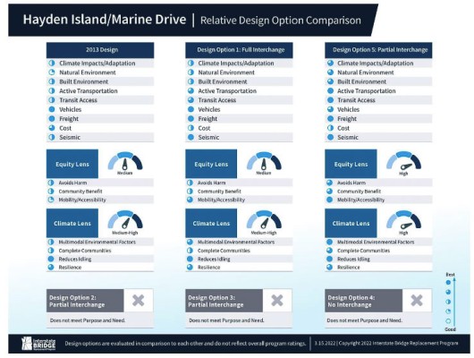
IBR’s partial interchanges on Hayden Island score better on climate and equity
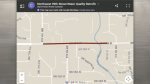
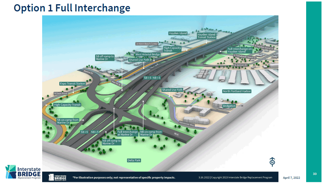
The current Interstate Bridge has a problem that contributes to traffic congestion. There are four interchanges within a two-and-a-half-mile area that cause a great deal of merging and weaving of vehicles. Key parts of this are connections to Hayden Island, as the interstate is the only way on and off the island for residents, shoppers, and businesses.
The Interstate Bridge Replacement (IBR) team has narrowed down the interchange options for handling Hayden Island traffic to two choices. One will have a full set of on and off ramps in both directions, like the current bridges. The second will have partial interchanges, where southbound traffic can exit I-5 directly to the island. Northbound traffic will also have an onramp to go north from the island. The balance will connect via a complex series of ramps and interchanges at the Marine Drive location, as a separate bridge will connect the island to north Portland.
When viewed through “climate” and “equity” lenses, it would appear the partial interchange solution scored better according to the IBR team. The details of the scoring system were not discussed at the April 7 meeting of the Executive Steering Group (ESG).
The IBR team has also decided to replace the north Portland Harbor bridge, something not included in the previous Columbia River Crossing (CRC) proposal that failed nearly a decade ago. This will add cost, but provide the IBR team flexibility in its design.
More details are being revealed with each meeting of IBR stakeholders. It is expected that major details like the choice for transit and the number of lanes will be announced on April 21. The current schedule shows the ESG has a meeting that afternoon, and earlier, there had been a call for the Bi-state Bridge Committee of 16 legislators to meet the same day.
So far we know the IBR has asked the US Coast Guard for a bridge clearance height of 116 feet for marine traffic on the Columbia River.
The IBR team noted several changes from a decade ago. The Port of Portland has decided not to build and develop a marine terminal on Hayden Island. The population has grown and the north Portland Harbor bridge has gotten older. There are proposed improvements to the levee system and businesses in the area.
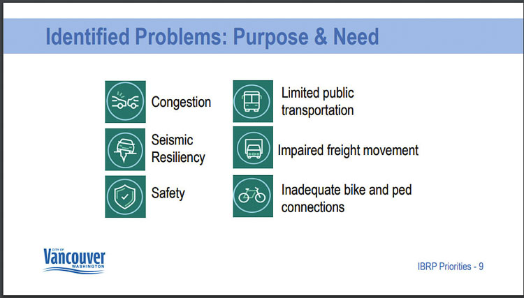
The project will be measured against the “Purpose and Need” statement which defines the problem to be solved. The six problems are traffic congestion, limited transit options, seismic vulnerability, impared freight movement, safety, inadequate bike and pedestrian connections.
In the current effort, the Purpose and Need has not been modified from the CRC. However the IBR team has added a “climate” and an “equity” set of lenses that will be applied to the project’s proposal.
The Purpose and Need statement defines the problem to be solved as part of the National Environmental Policy Act (NEPA) process. All proposed solutions are measured against the Purpose and Need statement to measure the viability of each possible solution.
Multiple community surveys have reported that 7 of 10 people want the project to reduce traffic congestion and save travel time. Washington citizens rate that even higher, with 78 percent wanting reduced congestion and time savings.
So far, no specific cost estimates have been provided to any of the decision making bodies for any of the options. The 2013 Locally Preferred Alternative (LPA) is scored better by the IBR team on cost, compared to either of their proposed options. The partial interchange option would appear to have much more concrete and vehicle interchange ramps and loops, likely adding to the cost, compared to the full interchange option.
The IBR team has only told citizens that “if” the CRC were built today, it would cost between $3.2 billion and $4.8 billion. Washington and Oregon legislators were informed each state would need to come up with “at least” $1 billion to fund their share of the project, and that tolling would be needed to cover some of the construction costs. That was before the federal IIJA was signed into law, providing $1.2 trillion in funding for infrastructure projects like the Interstate Bridge replacement.
In its short session this year, the Washington legislature allocated $1 billion from the $17 billion transportation package for the IBR. That will be added to nearly $100 million set aside from the 2015 gas tax package for the Mill Plain interchange at I-5.
The ball will be in Oregon’s court next year to decide its contribution. It would appear much more of the project’s construction and costs will be in Oregon. This is especially true with the decision to replace the north Portland Harbor bridge, and all the interchanges and infrastructure to be built at the Marine Drive and Hayden Island locations.
Will Oregon be required to pay for the larger share of the project? That hasn’t been addressed yet by legislators or key decision makers.
Also read:
- Delays expected on Northwest 99th Street during water quality project construction
 Clark County will begin construction in July to install a stormwater filter vault on NW 99th Street. Drivers can expect delays, but lanes will remain open during the work.
 - POLL: What’s the biggest concern you have with the current I-5 Bridge replacement plan?As costs rise and Oregon’s funding fails, concerns mount over the current I-5 Bridge replacement plan. Clark County Today asks readers: what’s your biggest concern?
- Plan ahead for ramp closures on I-5 near Ridgefield, July 8-9
 Travelers on northbound I-5 near Ridgefield should prepare for ramp closures July 8–9 as WSDOT crews conduct final testing of new wrong-way driving detection systems. The closures affect exits 9 and 11, including the Gee Creek Rest Area.
 - Oregon DOT director calls transportation funding bill failure ‘shocking,’ warns of layoffsODOT Director Kris Strickler warned staff that up to 700 layoffs are imminent after lawmakers failed to pass a transportation funding bill, deepening the agency’s $300 million shortfall.
- New crossing opens over SR 500 in VancouverWSDOT has opened a new pedestrian and bike bridge over SR 500 in Vancouver, restoring direct and ADA-accessible access for people walking, biking, or rolling.
- C-TRAN to hold groundbreaking for The Vine on Highway 99C-TRAN will break ground July 9 on The Vine’s Highway 99 extension, a new rapid transit line connecting Salmon Creek and downtown Vancouver.
- Opinion: ‘Southwest Washington residents deserve a better I-5 Bridge replacement project and a more reliable partner to complete it’Ken Vance criticizes Oregon’s failure to pass transportation funding, calling for a more dependable I-5 Bridge replacement plan and a trustworthy partner.
- City of Battle Ground announces speed limit reductions on multiple city streetsBattle Ground will begin installing lower speed limit signs starting June 30 as part of a safety-focused update approved by the City Council.