

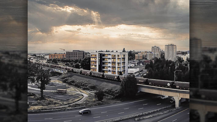
Hurley Building at risk of eminent domain by replacement Interstate Bridge plan
John Ley
for Clark County Today
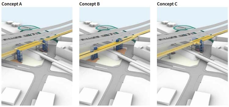
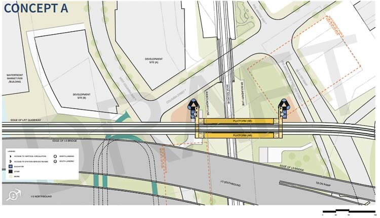
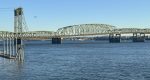
During a Community Advisory Group (CAG) meeting last Thursday afternoon (Jan. 11), the Interstate Bridge Replacement program (IBR) team revealed the first graphics on what three possible options for a proposed waterfront MAX light rail station could look like. They report the station’s elevation would be about 75 feet above the ground, potentially 15 feet lower than they told Sen. Lynda Wilson last month during a meeting of the Bi-state Bridge Committee of 16 Washington and Oregon legislators.
“This station is the most unique of all TriMet stations . . . in fact in North America,” said Mahlon Clements of the IBR design team. ”It needs to be very tall, very high off the ground because of how it comes off the bridge.” He noted they only found one very old station in Brooklyn that is taller, 87.5 feet.
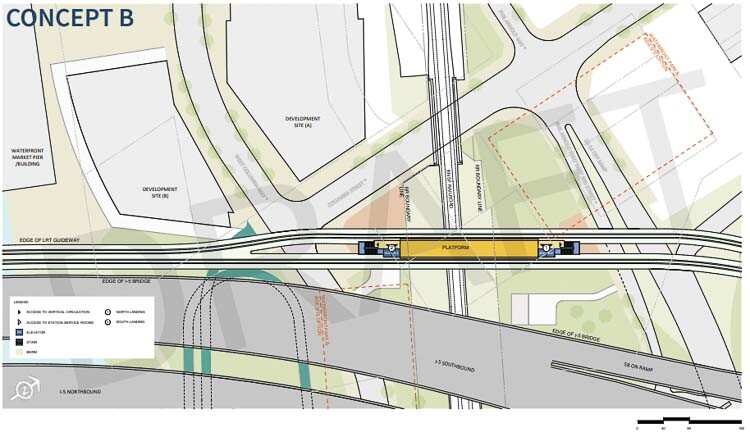
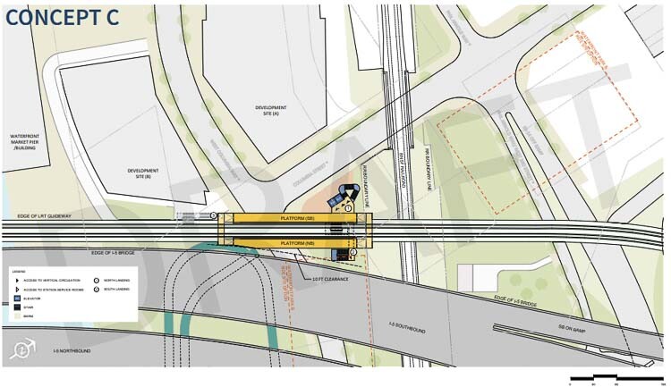
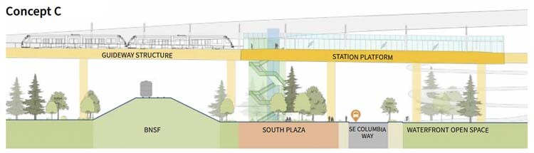
The three options or concepts for the MAX station include one south of the Burlington Northern Santa Fe (BNSF) rail tracks, and two that straddle the rail tracks. One concept has a shared platform in the center of the two sets of rail tracks. The other two concepts have two passenger platforms, one for southbound trains and the other for northbound trains.
Two of the options appear to have two sets of double elevators in addition to stairs. The other has a single set of double elevators. They didn’t provide a station option north of the rail tracks because it would be too close to the proposed Evergreen station, approximately 2,500 feet away.

Two of the possible design concepts put the Hurley Development building at risk of eminent domain seizure. The combination office and condo development was built in 2019. It supposedly has 42,600-square-feet of office space and residential living condos. One tenant, Johnson Bixby & Associates, appears to have signed a 305-month lease that lasts until August 2045.
The transit station would face several challenges. The two concepts over the BNSF rail line would require negotiations with the rail company for “air rights” to build above the train tracks. One also wonders if the Fire Marshall and Federal Transit Administration rules allow for a transit passenger station to be above an active railroad carrying hazardous materials. There are often unit trains of 100 cars or more carrying oil along the BNSF line.
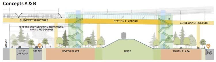
Additionally, the light rail station would have to leave at least 10 feet of clearance from the new bridge for maintenance, as the bridge design attempts to thread the planned Vancouver waterfront development. The noise from vehicles traveling the freeway would seem to have a very negative impact as well.
The stairs appeared to have five switchbacks for people to climb to the passenger platform. “It’s quite a hike up these stairs,” Clements said. “It’s within realm. We thought it’s still worth having a public staircase.” They expect most people would use the elevators.
Clark County Today shared the graphics with transportation architect Kevin Peterson. He noted that “side platforms served by two elevators tells me the design is intended to serve a minimal ridership. The layout shown suggests the investment is intended to serve less people than a downtown stop on a major bus route.”
When designing a station served by lifts, Peterson said you must assume one lift is out-of-service. “This means the design must accommodate all ridership in one lift,” he said.
Peterson estimated the elevators were standard sized, which would hold about five people plus one bicycle or about 30 bicycles and 150 people an hour. He estimated a round trip cycle time of the elevator to be close to two minutes.
He noted that Concept B has the stairs and elevators on both ends of the passenger platform. This would eliminate the ability to expand the number of train cars the station could handle in the future.
Peterson raised an interesting question. How many people does the IBR team estimate will be using the waterfront transit station? TriMet only runs 2-car trains every 15 minutes. That indicates the light rail could carry at most about 1,000 passengers an hour, leaving no room for people in north Portland.
IBR Administrator Greg Johnson’s team has officially projected 26,000 to 33,000 daily transit riders on the I-5 corridor in 2045. They call this a ten-fold increase, which in reality would be closer to a hundred-fold increase over today’s ridership. Some Washington legislators have been skeptical of these numbers, especially when weighed against a $2 billion expenditure for light rail on the IBR.
C-TRAN offers the only transit service over the river. It reported less than 1,000 people a day use the I-5 and I-205 express buses for travel to Portland. One legislator told Johnson: “If I take those numbers to my constituents, I’m f***ed!”
CAG member Irina Phillips expressed worries about the height of the structure and passengers waiting for the train to be exposed to wind and rain. “For me, after seeing this presentation, I don’t feel comfortable,” she said. Phillips wondered how welcoming the structure would be in the fall and winter.
The design team mentioned that they expect some level of wind and rain protection to be included in the final design. Because of the height, they aren’t planning an “accessibility ramp”.
Transit connections with C-TRAN would occur on Columbia Street. A nearby park and ride facility is also being considered.
According to the IBR design team, this is the beginning of a “dialogue” where they are seeking feedback and community input on these “concepts.”
The CAG was reminded of the “Community Values and Priorities.” They include increasing the capacity of river crossings and congestion relief. They were told transportation facilities must remove barriers, yet the height of the transit station appears to be a significant barrier.
“If the project is data driven, then the ‘fit for purpose’ solution suggests data does not justify light rail,” said Peterson. His calculations indicate bus rapid transit (BRT) could more than adequately serve Clark County through about 2080. He wondered if TriMet even has projected data on how many people will use this station.
Peterson said if he were to bring this concern to the project office, they would likely respond that the stairs provide the lost capacity of a disabled lift – which would be acceptable if the climb was less than 30 feet.
“It’s clear to me the design is another reflection of an LRT (light rail transit) investment that allows a certain constituency to ‘feel good’ without reversing the TriMet decline in transit ridership,” Peterson said. “It provides funds to an underutilized transit infrastructure, and does not provide meaningful qualitative advantage to life in downtown Vancouver.”
The 3-mile MAX Yellow Line extension to Hayden Island and two stops in Vancouver is projected to cost in excess of $600 million per mile. It currently has the second lowest ridership in the TriMet light rail system.
In November, weekday ridership on the five MAX lines averaged 32,460 on the Blue Line, 12,130 on the Red Line, 13,580 on the Green Line, 9,990 on the Yellow Line, and 6,960 on the Orange Line. Total MAX ridership increased 14.2 percent during weekday peak and 15.5 percent during weekday off-peak periods, resulting in a 15.1 percent increase in weekday MAX ridership.
The Delta Park MAX station has 531 boardings on an average weekday. Currently, the MAX system ridership is 33 percent below January 2020 ridership, or over 600,000 average weekly riders. MAX ridership dropped by about two thirds due to pandemic lockdowns and is slowly recovering.
During the recent freezing weather event, MAX was shut down for three days. Freezing rain is in the forecast, potentially impacting TriMet plans for a return to service.
Overall, Peterson wishes the community would demand an immersed tunnel or high-level express bridge. He would repurpose the existing two bridges, allowing them to serve as a collector distributor (CD).
“This allows the express freeway to be a four-lane road that bypasses the five interchanges in three miles,” Peterson said. “The current project seems content to ignore even if this violates the WSDOT Design Manual. The existing roadway would then serve double duty as an urban arterial and CD.”
“This is much better for it adds capacity (four lanes), tames the noise of the freeway hovering over the urban setting, and can eliminate all the proposed expensive ramping spaghetti that will compromise the livability of Vancouver and Hayden Island,” Peterson concluded.
Peterson suggests the community hold the IBR team to the WSDOT Design Manual with respect to a collector-distributor. This criterion is consistent with other DOT manuals, he points out. An immersed tunnel or higher bridge could be constructed. “Imagine that – a less costly solution offering a 100 percent capacity increase!”
Peterson later elaborated on his thinking.
“A ‘data driven’ station design relies on and meets ridership estimates, safety, and desirability issues. This is often referred to as ‘fit for purpose’. I’m suspicious of any high-capacity transit station layout that’s publicly tabled without sharing the ‘data’ which informed the design. Qualitatively, I’m struck with how undesirable the station will be nested within the noisy freeway.
“Without ‘data’ I suspect the station has minimal ridership as minimal lift provisioning is included as transit designers must assume only one lift is available and the other is out of service. This suggests just a handful of people are expected to meet trains at this station. Without ‘data’ derived from negotiations and agreements with the railroad, bringing to account things like exploding tank cars under a public gathering place, I’m suspicious the design may not adequately consider potential fire, life, safety concerns.
“This is a concern because it may be a bit too early to publicly share layouts that may not prove the test of yet to be discovered ‘data’. More critically, I’m struck with how few people are expected to use the station.
If this station is designed to meet the travel needs of a reasonable percentage of people living and working in the downtown Vancouver station catchment area, which I suspect is many thousands of people, I’d then expect a station accommodating something like three to five hundred station peak hour users growing to a thousand plus in the next decade.
“It would be good for the transit authority to share the ‘data’ driving this layout for without this data it’s hard to judge if the layouts are appropriate or, given what I suspect is very low ridership, even if the station is needed.”


Also read:
- Opinion: Neighbors for a Better Crossing calls for a current seismic study for $7.5 Billion Interstate Bridge project
 Neighbors for a Better Crossing is urging a new seismic study before construction proceeds on the $7.5 billion IBR project, raising transparency concerns and proposing an immersed tube tunnel alternative.
 - Rep. John Ley supports C-TRAN Bus Rapid Transit to save Washington moneyRep. John Ley praised C-TRAN’s new BRT line as a faster, lower-cost alternative to light rail, urging support for transit options that save taxpayers money and improve service.
- C-TRAN, WSU Vancouver celebrates groundbreaking for The Vine on Highway 99C-TRAN and WSU Vancouver broke ground on the Vine’s Highway 99 route, a 9-mile bus rapid transit line connecting the university to downtown Vancouver and the Waterfront, set to open in 2027.
- C-TRAN board again postpones vote on light rail operations and maintenance costs
 The C-TRAN board again postponed a vote on language regarding operations and maintenance costs tied to light rail expansion, with pending lawsuits involving Michelle Belkot continuing to impact board actions.
 - Opinion: ‘The Interstate Bridge project lacks billions in funding from both Oregon and Washington’Lars Larson criticizes Oregon’s funding decisions, highlighting the billions missing from both states for the Interstate Bridge replacement project and calling it a dead-end effort lacking Coast Guard approval.


From the article: “The CAG was reminded of the “Community Values and Priorities.” They include increasing the capacity of river crossings and congestion relief.”
The overlords forget that NOT WASTING $2 BILLION on 1000 riders IS NOT a “Community Value” or a “Priority”. Just in case they are having trouble with grade school arithmetic, that is $2 MILLION DOLLARS to accommodate each daily rider.
Commuters will not likely use Max from Vancouver as too much time is involved in making connections to any other part of the metro area from downtown Portland with public transportation. Nowadays people will not use public transportation due to the level of personal safety where crime is rapidly increasing, particularly in Portland. We need additional bridge(s) with other connections in and around the metro. How come these project members keep coming back to the same identical “project killer” ideas again & again?
Donna –
Another reason most people will NOT use the MAX Yellow Line is that it only travels at 14 mph. Nobody wants to travel that slow.
3 pictures of MAX line failures during below freezing temps
https://www.kptv.com/gallery/2024/01/15/trimet-max-service-still-disrupted-sunday/
In an update Tuesday morning, TriMet said while most MAX lines remain impacted by weather, all bus lines are operating Tuesday.
https://www.kptv.com/2024/01/16/max-blue-line-resuming-service-after-portland-weather-forced-suspension/
TriMet said Friday (Jan 19) at 7:30 p.m. that crews are continuing to work to reopen MAX service further, but it does not have an estimated reopening time.
Shuttle buses are carrying travelers along all MAX lines, including the Blue Line segment from Rose Quarter to Cleveland Avenue in Gresham and the Yellow Line segment through Downtown Portland.
https://www.kptv.com/2024/01/20/trimet-max-blue-yellow-lines-partially-open-after-winter-storm-portland/
pretty sure we the voters have voted against lite rail multiple times. Why is it so difficult for those in power to not be smart enough to figure out we need multiple plain additional bridges????? You do not need to replace an existing bridge. Maybe if they were required to pay for it they may get the message. lite rail is a waste of money as are most politicians.
In November 2012: -Clark County voters REJECTED the C-Tran ballot proposition to raise the sales tax to extend Oregon’s TriMet Max light rail into Clark County. Every city in Clark County rejected the CTRAN Proposition, as did limited county area permitted to vote.
November 2013, Clark County Councilors placed an advisory vote on the ballot to oppose any Light Rail project in Clark County unless it is first supported by a majority of the voters in a county-wide advisory vote of the people. Over 68% of voters approved the measure. No county-wide advisory vote on light rail has been held since then.
Overpaid Politicians in both Washington and Oregon. No vision at ODOT or WASHDOT as there already should be a Columbia River crossing East of 205 and West of I-5. 40 years and all we get is ramming Loot Rail down our throats that nobody wants, and how many Millions squandered already? Probably could have BOTH Bridges paid for already if some people on both sides of the river were actually serving the populace.
All of this money money money, time and effort. We could have had a third bridge built by now.
Remember……when the I35 Bridge collapsed in Minneapolis it only took a little more then a year to build it back. It only took MDOT a few days to put the new bridge plans together….a few days. The Pat Tillman Arizona Nevada bridge took what 7 years…and it did not cost $9billion…..only $240 million. The real issue is our Washington state legislature is compromised. WSDOT leader needs to retire or fired. If we could get a Republican Governor maybe that person would have the guts to tell Oregon…..Hello…and Hell no we want a 3rd bridge. But keep in mind, even with all of these known issues all 3 of your Vancouver locally elected Democrats are ALL-in on this fiasco….because they do think for their constituents….only the collective.
Something more to think about….a huge issue is we are preaching only to ourselves. We really have no audience. That is because we do not have anyone in an elected position in Southwest Washington with enough courage to constantly challenge what is said.
By that I mean an elected official needs to create public displays of resistance. Create situations where the Columbian \ Oregonian has to cover it. Keep the pressure on the City of Vancouver, Clark County Councilers and foremost WSDOT.
We need that elected official to step-out, draw a line in the sand and stand on it. Until that happens this bridge will be built.
Clark County Councilors hold meetings nearly weekly, so speaking up for a third bridge WITHOUT light rail could help.
City Councils send representatives to CTRAN who support light rail, even though the citizens of the cities have voted against it. People who live in cities can attend their council meetings and express their concerns.
Government has forgotten who they work for.