

Interstate Bridge Replacement Program team shares renderings that raise concerns about how little natural light would reach the path
Ryan Packer, contributor
BikePortland
After months and months of draft renderings from the team behind the planned expansion of I-5 between Washington and Oregon that focused on the highway, on Thursday the public finally got a look at what a potential bike and pedestrian path being planned as a part of the project could look like.
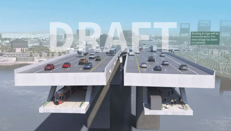
At a meeting of regional leaders, the Interstate Bridge Replacement project team showed a rendering depicting twin six-lane bridge structures, including shoulders, with a light rail train below one of the structures and a bike and pedestrian path below the other. Bizarrely, both areas below the highway are shown in darkness, with no lights depicted on renderings of people using the multi-use path. This has the effect of illustrating how little natural light would reach the path. About a third of the area available below the highway next to that path is shown taken up by mechanical equipment.
It’s not yet clear what the need might be for mechanical equipment underneath the bridge that could take away space from the walking and biking path. During the meeting, IBR program administrator Greg Johnson noted that the project team was in talks with US Senator Jeff Merkley about including a “smart highway” concept in the design that could include electric vehicle charging capabilities for drivers traveling at “freeway speeds.”
Portland Commissioner Jo Ann Hardesty pushed back on that concept. “90% of the people I know will never be able to afford an electric car, and so if we’re going to be increasing the cost [of the highway] significantly so that people who can afford electric cars can charge it on their way to work, I think we need to have a conversation about that, because that’s an equity issue that would severely impact some populations at the expense of others.”
The rendering doesn’t show any of the approaches to the shared use path on either side of the river, with those still depicted as a generic 3D circle in project renderings. Earlier this year, immersed tube tunnel advocate Bob Ortblad made his own calculations to depict what those ramps might look like. But those drawings drew direct criticism from the project, even as they have not been able to provide their own. That may be partly due to the fact that negotiations with the US Coast Guard are ongoing, after an initial analysis suggested that the IBR design was 60 feet too short to receive Coast Guard approval.
Johnson was emphatic in noting that the rendering shown Thursday is just a “draft concept.” “We have not made a decision on configuration, on bridge type,” IBR program administrator Greg Johnson told the project’s executive steering group. “We know that aesthetics are important for this region, so we are looking at different bridge types that will achieve the aesthetic value at a cost that is going to be acceptable to the partners.” Johnson noted that the IBR has run into issues designing a side-by-side highway project that did not encroach on Fort Vancouver, which he called a “red line” for the project.
The megaproject is steaming toward environmental review, when more details should be forced into public view. After the draft locally preferred alternative was approved nearly unanimously earlier this year, the next big milestone for the project will be next summer, when the public comment period for the project’s Supplemental Draft Environmental Impact Statement opens. Before then, we should have a better look at what the walking and biking path will look like, rather than being kept in the dark.
This story was originally published by BikePortland.
Also read:
- Clark County beginning installation of upgraded traffic signals in mid-April
 Clark County will begin upgrading multiple traffic and pedestrian signals in mid-April to improve safety, accessibility, and transportation technology.
 - Can $10 tolls be coming to the Interstate Bridge?
 Rep. John Ley examines a proposed Washington House bill that would double borrowing for the Interstate Bridge Replacement and potentially lead to high tolls affecting Southwest Washington drivers.
 - Overnight full closure of I-5 in north Clark County for utility work, April 13Both directions of I-5 in north Clark County will be closed early Sunday morning, April 13, for utility work involving overhead power line relocation.
- Opinion: The stage is set for a battle royaleRep. John Ley outlines key legislative battles in Olympia, raising concerns about tax hikes, tolling, and spending priorities in Washington state.
- Inflation worries drive WA lawmakers to jack up I-5 bridge borrowing plan by $900MLawmakers in Washington have added $900 million to their borrowing plan for the I-5 bridge replacement, drawing opposition from Rep. John Ley.


Nope, nope, nope