Draft Supplemental Environmental Impact Statement delayed for 4th time
John Ley
for Clark County Today
A portion of the Draft Supplemental Environmental Impact Statement (DSEIS) for the Interstate Bridge Replacement (IBR) Program has been revealed, not by the program but due to a Public Records Request made by the Just Crossing Alliance (JCA). The program appears to be concerned that the revelation of the information will trigger a “negative public reaction,” and “hinder the decision-making process,” reports Joe Cortright.
Less than a week later it was announced the publication of the DSEIS has been delayed until much later this year. IBR critic Bob Ortblad notes this is the fourth time it has been delayed. “The IBR has no credibility,” he said. “The Federal Agencies are not buying IBR’s freeway expansion, dangerous bridge, and environmental disaster.”
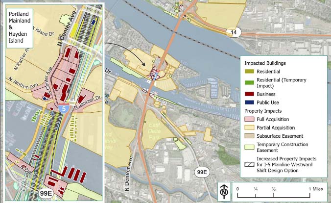
The JCA-released documents are 694 pages, but not the complete DSEIS. Among missing documents are specific addresses of properties impacted that the LPA would require eminent domain process to acquire. There are 36 single-family residences, 22 retail or services businesses and one office displaced. Maps show their locations.
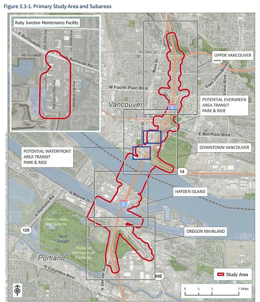
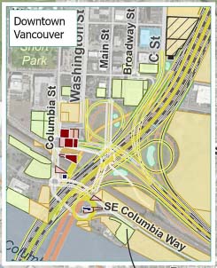
In Vancouver, there are seven single-family homes and 10 office, professional businesses to be taken. The houses appear to be on the west side of I-5, south of 38th Street. One IBR option would shift the bridge alignment west. If that were done, then an additional 33 multifamily residential units and three retail businesses would be taken in property acquisitions.
On Hayden Island, “up to 35 floating homes in North Portland Harbor would be displaced by the Modified LPA. Floating homes would be treated as personal property and would be relocated to moorages within the area if available.” Additionally, 14 Hayden Island businesses would be displaced, plus an unspecified number of “marine businesses” on the south side of the north Portland harbor.
The report notes “(d)aily traffic demand over the I–5 crossing Interstate Bridge is projected to increase by more than 35 percent during the next 20 years, with stop–and–go conditions increasing to approximately 15 hours daily if no improvements are made.” It further adds: “(t)he hours of congestion and delay refers to the total number of hours that the corridor experiences congestion. Congestion on a highway occurs when average speeds are below 35 miles per hour.” There is no explanation as to why they are replacing an over congested three-lane bridge with another three-lane bridge.
Freight volumes are projected to more than double over the next 25 years. “Vehicle-hours of delay on truck routes in the Portland/Vancouver area are projected to increase by more than 90 percent over the next 20 years,” they report. “Growing demand and congestion will result in increasing delay, costs and uncertainty for all businesses that rely on this corridor for freight movement.”
The IBR program’s April newsletter says the following about the DSEIS and the process. “This comprehensive and careful review is intended to ensure the accuracy of the Draft SEIS and enable the public to provide comment on the correct information during the public comment period.”
Program Administrator Greg Johnson told community leaders “time is money” as he pushed to keep a host of committees and oversight organizations on track. He recently put a dollar figure out – $300 million for each year the project is delayed. Will the delay in releasing the DSEIS add $300 million to the cost of the project?
The plan reveals that 43 single-family residences and 35 commercial businesses will be taken by the project, including the five-year-old Hurley Building. Hayden Island would supposedly experience both “positive and negative changes.” Two public facilities would be impacted as well.
The 694 pages within the documents show the following, dated April 2023.
Parcels that would require acquisition:
- 45 full
- 131 partial/subsurface
Land uses that would be displaced:
- 43 single-family residences
- 35 commercial businesses
- 2 public facilities
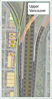
These homes along the west side of I-5 just south of the 38th Street will be impacted by the proposed Interstate Bridge Replacement project. It appears that 7 single family homes will be taken if the project is approved. One option for a western location for the bridge would claim an additional 33 residences in a multifamily unit in downtown Vancouver. Graphic courtesy IBR
Additionally, the following public property will be required as part of their Locally Preferred Alternative (LPA). (Numbers in square feet).
- Old Apple Tree Park – 3,480
- Fort Vancouver National Historic Reserve – 40,984
- Fort Vancouver National Historic Site – 18,255
- Columbia River Renaissance Trail – 1,007
- Lewis & Clark National Historic Trail – 173
- Lower Columbia River Water Trail – 173
- Discovery Historic Loop Trail – 2,759
There would be “temporary disturbances” of more than double the Ft. Vancouver Historic lands (above) and the other sites, during construction. “Hayden Island would experience both positive and negative changes to neighborhood cohesion including negative impacts from visual changes (larger scale than existing bridge) and residential and business displacements, as well as benefits from changes to access and circulation.”
While the project is supposed to be about the “5-mile bridge influence area,” the DSEIS shows the acquisition of property in Gresham. TriMet’s Ruby Junction maintenance facility will apparently be expanded by the IBR, with seven properties acquired in full or in part. Why is an expansion of a maintenance facility required for a three-mile extension of an existing MAX line?
Once again, this same facility was included in the failed Columbia River Crossing (CRC) and was viewed skeptically. In the CRC, TriMet demanded 19 new MAX light rail vehicles. The IBR appears to be seeking the same number now. In contrast, TriMet only bought 4 new light rail vehicles for its current 10-mile “Better Red” extension into Hillsboro.
The original release of the DSEIS was supposed to be in 2023.
The beginning of these setbacks appears to have begun when the US Coast Guard demanded the project consider a movable lift span. This followed the public comment period on the IBR’s request to build a bridge offering only 116 feet of clearance for maritime vessels on the Columbia River. The Coast Guard asked for at least the current 178 feet of clearance and preferred “unlimited” clearance that would be offered either by a tunnel or a bascule bridge.
In the failed Columbia River Crossing, the plan was to “mitigate” three up-river firms, paying them $86.4 million. Today, there are at least four firms claiming harm. The program has required them to sign non-disclosure agreements. In December, the IBR’s Ray Maybe told the 16 legislators of the Bi-state Bridge Committee that they expected to have those mitigation agreements wrapped up by the end of the first quarter.
One might wonder if the delay in the DSEIS is in part because the project has been unable to reach agreement with all the firms requiring mitigation. Alternatively, might the delay be due to the Coast Guard’s unwillingness to accept a “bridge too low?”
In December, Johnson told the 16 members of the Bi-state Bridge Committee of Washington and Oregon legislators that the cost of the project would be adjusted upward, again. The current time frame for releasing the new numbers was supposedly this summer. Cortright predicted the current $5 to $7.5 billion price tag would increase 20 percent to $9 billion. Could there be an additional delay in getting updated cost information, as a contributing factor impacting the DSEIS?
The size of the bridge itself would increase by 38 percent on one option and 49 percent on another option. The Modified LPA is a double-deck bridge that would have 455,550 square feet of deck space, corresponding to the 38 percent increase. The other two single-deck options would have 491,180 square feet.
All proposals only have three through lanes for vehicle traffic, plus an auxiliary lane for merging and weaving at on/off ramps. C-TRAN would be allowed to run Bus on Shoulder (BOS) on its Express bus service into Portland. This would be in addition to the inclusion of MAX light rail.
The program shared the following with Clark County Today. The goal remains to begin early construction activities in late 2025/early 2026.
“The Interstate Bridge Replacement program has been working toward the goal of publishing the Draft Supplemental Environmental Impact Statement this spring. With technical review still underway, we no longer expect that timeframe to be feasible, and are working with our federal partners to identify the anticipated timing of the publication later this year.
“It is not unusual for complex mega projects like the IBR program to experience a shift in the timeline.”
There are many more details to be ferreted out. Citizens will be given only 60 days to make public comments once the DSEIS is published. The more they learn now, the more informed their input will be once the final details are formally released.
Also read:
- Busy pavement season ahead on Vancouver streets
 The city of Vancouver is set to repave and preserve 76 lane miles across 20 neighborhoods in summer 2025, with ADA upgrades and community notices throughout.
 - State representative: Expect sticker shock when Interstate Bridge project officials reveal price, tolling plansAt a town hall in Battle Ground, Rep. John Ley warned of major cost increases and tolling burdens tied to the Interstate Bridge replacement project.
- Opinion: Washington state lawmakers increase the cost of driving – againBob Pishue of Mountain States Policy Center argues that new vehicle and fuel taxes in Washington will raise driving costs while diverting funds away from roads.
- Overnight full closure of I-5 near Woodland for bridge inspection, May 6
 WSDOT will fully close southbound I-5 near Woodland overnight on Tuesday, May 6 for a bridge inspection using a chain drag test.
 - Opinion: Do we still need TriMet?John A. Charles Jr. of the Cascade Policy Institute argues that TriMet should halt expansion plans and prepare for major service reductions in response to falling ridership and rising costs.